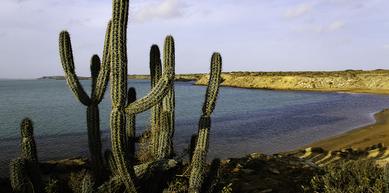
| Day 1 | Punta Gallinas – the Northernmost point of South America
With a name that does relate much to the place (Chicken point), it is definitely one of the most unique spots in the country. Located in the upper most point of Colombia and the South American continent, Punta Gallinas offer some of the most amazing beaches to be found along the Caribbean coast. Punta Gallinas, originally a lighthouse, now in ruins is 3-4 hours drive Riohacha. To get there, first a good road “Cuatro Caminos” a 4 roads intersection in the middle of nowhere and then north by the main road, passing in the distance Uribia, the Wayuu capital and also named the Indigenous capital of Colombia. After about 1,5 hours drive, the tour goes into the Colombian “outback” driving over a desert with only 4-wheel drive’s tracks to the followed. The landscapes get wilder and, the indigenous families living out there, have a hard daily life. During the roadtrip two bays will be passed: the Bahia Ondita y Bahia Onda, with amazing landscapes, open skies and colorful sand beaches. After 2 hours drive in this remote land, the sand dunes of Taroa will be reached. This is the highlight of this area, a place just our of a story, nothing to relate Colombia a tropical country with. The yellow sands falling down the hill into the roaring sea. Sunset here is a must and an experience of a life time.
Punta Gallinas, where the ruins are, has a nice beach with an incredible turquoise sea and the view into an endless ocean! By the way….you are not very likely to be surrounded by many people, if any at all!
The night will be spend in a local home-stay build and run by the local Wayuus, also part of the trip’s experience.
Night in rustic lodge
Included meals: Breakfast, Picnic, Dinner |
| Day 2 | Cabo la Vela
Morning visit to enjoy the beautiful beach of “Punta Aguja”, there is the optional boat ride to Hondita Bay to spot pink flamingos (this tour is not included, but can be ordered the night before). After lunch, departure from Punta Gallina crossing once again La Alta Guajira’s deserts, until the Cerrejon Railroad (Cerrejon is the biggest open sky coal mine in the country), from where the road to Cabo la Vela starts. The last section, is more inhabited that the desert up North, and here lies one of the only windmill parks in the country.
A 2-3 hours desert road trip from Punta Gallinas is what it takes to get down to El Cabo de la Vela, located on the Wester coast of the Guajira peninsula, South from Punta Gallinas. It has a some best beaches, very little visited, only crowded during the Colombian holidays. Otherwise, an idyllic spot to relax and enjoy the nature. The place is great to get lost in the many bays, desert trails and also exploring the local cuisine and traditions. The place is inhabited by the Wayuu indigenous group and it is possible to sea the traditional fishermen work, bringing the sea harvest a shore in the early mornings.
El Cabo is also very popular for those into kite surfing, its permanent wind currents make it ideal for this sport. For those interested, it is possible to take a short course or rent the gear (not included).
Again taking a walk up to “El Cabo” lighthouse to enjoy the sunset, it is a must.
Night in rustic lodge.
Included meals: Breakfast, Lunch, Dinner |
| Day 3 | Cabo de la Vela – Santa Marta
After breakfast, departure to Manaure, where we will visit the Wayuu’s salt ponds and experience this traditional technic to extract salt. All guided with a community leader.
Time to share with the community, in the Wualapuinje ranch, where you can learn about rituals and traditions, before starting the trip back down to Riohacha after a nice local lunch. The road trip follows the desert, if dry, over a salt flat and then close to the railroad until cuatro Caminos, from there a short 1,5-2 hours to Riohacha and then ” La troncal del Caribe” highway will cross the Souther Guajira and down to Magdalena State. Final destination is Santa Marta city, about 2 hour from the state border.
Afternoon free to enjoy the city.
Night in hotel.
Included meals: Breakfast |
| Day 4 | Santa Marta & City Tour
In the morning hours there will be a 3 hour city tour in Santa Marta, actually the first established town in Colombia by the Spanish in 1534. The tour will visit the most iconic places in the city like: The Cathedral where Simon Bolivar was buried before he was moved to his birth place and last resting place in the city of Caracas. A walk through the colonial streets of the city’s crowded downtown. The gold museum, even though a much small collection in comparison with Bogota’s, it offer a great insight into the native culture inhabiting there surrounding areas. The seaside promenade and the pier and the Plaza Bolivar.
The tours ends around noon. Free afternoon.
Night in hotel.
Included meals: Breakfast |
| Day 5 | Lost City – Trekking: “Donde Adan” lodge (480 m)
The Lost City Trek is one of Colombia’s most iconic and unforgettable adventures. Nestled deep in the Sierra Nevada de Santa Marta mountains, this multi-day hike takes travelers through lush rainforests, pristine rivers, and remote Indigenous villages to reach Ciudad Perdida—an ancient archaeological site older than Machu Picchu. Built by the Tayrona civilization around the 9th century, the Lost City features stone terraces, ceremonial plazas, and breathtaking views. Morning pick-up at the hotel and transfer in 4WD vehicles, driving northeast along the Caribbean coast. After 1 to 1.5 hours, we leave the paved road—and this is where the adventure begins! After approximately a 1-hour drive on a dirt road through a beautiful landscape, we reach the village of El Mamey (150 m), also known as Machete Pelado. Lunch will be served upon arrival, and then the hike to Ciudad Perdida begins. This day’s hike is exposed to the sun or rain, so it is important to bring plenty of water and sunscreen. Tropical fruits will be offered along the trek. The group will follow the river trail, which is a more pleasant walk than the main road. This path follows the Quebrada del Alto Mamey river valley for about one hour and then ascends steeply (1.5 hours) to El Mirador pass (640 m), which offers a fantastic view over the town of Mamey and the Buritaca River. From this point, the trail descends steadily (1.5 hours) to the Quebrada Honduras river, where Donde Adán lodge is located. It is possible to take a refreshing swim in a beautiful natural river pool near the lodge. Dinner will be served in this rustic accommodation. Overnight in hammocks or bunk beds. Ascent: 490 m / Descend: 160 m / Highest altitude: 640 m / Distance: 8,9 Km / Activity duration: 4 h
Included meals: Breakfast, Picnic, Dinner IMPORTANT INFORMATION FOR THE LOST CITY TREK:Yearly closures: – The Lost City Trek closes once a year to allow Indigenous communities to carry out traditional religious ceremonies. This closure usually takes place in September or October and typically lasts for the entire month. If you are planning your trip during this period, please contact us to confirm the exact closure dates, as they may vary slightly from year to year. – This itinerary reflects the standard program and may be subject to changes due to weather conditions or unforeseen circumstances beyond our control (force majeure). |
| Day 6 | Trekking: “Paso Lorenzo” lodge (806 m)
This is the longest day of the Lost City trek. After an early breakfast, the ascent begins immediately, following a well-marked trail that gently gains elevation up to the Mumake Pass (680 m). Before reaching the pass, hikers will cross an invisible border between the lands of the Colonos (peasants not originally from the area) and the territory of the Kogi (an Indigenous people). From this point onward, the trek continues through an area protected and governed by this tribe. The region is also home to Wiwa communities—Indigenous people originally from another part of the Sierra—who have since settled in these valleys and now operate some of the local lodges. A noticeable shift occurs here: expansive farmland gives way to a more pristine and less exploited environment. From the pass, the trail descends quickly into the Buritaca River valley (430 m), where the trek’s only Kogi settlement, Montangi, is located. This is a great opportunity to observe and appreciate local traditions and ways of life. After about an hour, a hanging bridge crosses the river, leading to a second ascent (approx. 2 hours) up to Koskunguena Pass (824 m), before descending again to the Buritaca River (743 m), and finally reaching the rustic lodge Paso Lorenzo (806 m), where you’ll spend the night. This lodge, located beside the river, is an ideal spot to relax and enjoy a refreshing swim. Overnight in hammocks or bunk beds. To Mumake pass: Ascent: 200 m / Descend: 250 m / Highest altitude: 680 m
To Koskunguena pass: Ascent: 394 m / Descend to Buritaca River: 77 m / Highest altitude: 824 m / Distance in all: 12.94 Km / Activity duration: 6 h
Included meals: Breakfast, Picnic, Dinner |
| Day 7 | Trekking: Lost City (1175 m)
We depart very early, continuing along the same trail, crossing and following the banks of the Buritaca River for about 40 minutes until we reach a second crossing. Once on the other side, the ascent begins along a steep stone path, leading to the first terraces of the Lost City (1,175 m). From this point, a journey through time begins, taking us to one of the most fascinating archaeological sites from Colombia’s pre-Hispanic era. The Lost City of the Tayronas—originally known as Teyuna—is internationally renowned and is one of the three great citadels of the vanished Tayrona civilization. Teyuna is the only one discovered so far, and thus the only one partially restored. The Tayrona cities were connected through an intricate network of roads, linking the Caribbean coast with the high mountains of the Sierra Nevada de Santa Marta. The Tayrona had a highly developed social structure and an efficient system for exchanging products and goods among settlements. Although there is no definitive information about the specific role of Teyuna in Tayrona society, it is believed to have been both a religious sanctuary and a political center. During the 3-hour visit to the archaeological complex, you will explore different types of terraces and how their placement reflected social hierarchy and designated functions. During the visit, it is also possible to see the house of a Mamo Kogi (shaman), who continues to preserve his people’s traditions and cosmology. After the visit, the hike continues to the “El Paraíso” lodge for lunch, and then resumes (4 hours), following the same trail as the previous day but continuing further. You’ll cross a suspension bridge and descend through the Buritaca River valley, passing once again through the Kogui settlement of “Montangi” before reaching the “Mumake” lodge (389 m), located at the foot of the Mumake Pass. Overnight in hammocks. Overnight in hammocks or bunk beds. To Lost City: Ascent: 369 m / Descend back to lodge: 369 m / Highest altitude: 1175 m / Distance one-way: 2,4 Km / Activity duration: 5 hours including a 2 hours visit.
Ascent to Koskunguena pass: 77 m / Descend to “Mumake” lodge: 481 m / Highest altitude: 870 m / Distance one-way: 7,64 Km / Activity duration: 4 h
Included meals: Breakfast, Picnic, Dinner |
| Day 8 | Trekking: El Mamey (150 m) – End of trek
Last day of trekking! From the “Mumake” lodge (389 m), the ascent is direct to the “Mumake” Pass (680 m), followed by a descent to the “Quebrada Honduras” river. Then, a 1.5-hour ascent leads to the final pass, “El Mirador” (640 m), and finally, the route descends to the last destination, “El Mamey” (150 m). Upon arrival, lunch is served, followed by a transfer to the hotel. Ascent to Mumake Pass: 291 m / Descent to “Donde Adán” lodge: 200 m / Ascent to El Mirador Pass: 160 m / Descent: 490 m / Maximum altitude: 680 m / Distance: 14.2 km / Activity duration: 4–5 hours.
Included meals: Breakfast, Picnic |
| Day 9 | Tayrona National Park
Full-day tour to the Tayrona National Park. This is one of the most famous natural parks in Colombia with some of the most beautiful beaches of the Colombian Caribbean coast, right at the foothills of the Sierra Nevada de Santa Marta, the world´s highest coastal mountain range. The park has a protected area of 150 km2 of land and 30 Km2 of sea, being the second most visited park in the country. Due to its privilege location, there is a huge biodiversity and also archeological ruins like “Pueblito”.
From the park’s main parking lot there is a light hike by the beach line to the Arrecife’s area (1 h), an iconic place within the park. From there, another 25 min. to La Piscina beach and 20 min. more to El Cabo San Juan. There will be good time to enjoy these idilic Caribbean beaches and the nature of the place. Lunch will be held at a local place, where they prepare traditional fish. On the afternoon, return back to lodge. Remark: the guide will adjust the length and itinerary according to the clients interest and capabilities.
Distance round trip to Cabo San Juan: 14,87 Km / Activity duration: 5-6 h
Included meals: Breakfast IMPORTANT INFORMATION FOR THE VISIT TO TAYRONA NATIONAL PARK:Due to regulations established by local Indigenous communities, Tayrona National Park will be closed three times a year during the following periods: * February 1st to 15th
* June 1st to 15th
* October 19th to November 2nd If you are planning your trip around these dates, please check with us to confirm the park closure, as the exact dates may vary from year to year |
| Day 10 | Santa Marta – Departure
Pick up and transfer to Santa Marta’s airport (1,5-2 h).
Included meals: Breakfast |